
The trail is 32 miles of flat, smooth, asphalt surface from Oil City to Emlenton.
Through Sunny Slope, 14 miles south of Franklin, take the dirt road about a 1/2
mile until it reconnects with the paved trail. Bordered on the west by the
Allegheny River and on the east mostly by woodland, the 8-foot wide paved surface
built on an old railroad grade is parallel to a dirt access road suitable for
horses. The trail is marked through Oil City to the north to the intersection
of Seneca Street and Route 8. To the south, the trail is complete through the
old Quaker State Refinery in Emlenton and ends at the parking lot at the edge of
town.
There are two railroad tunnels on the ART. The Kennerdell Tunnel, 3350' long,
is 15 miles south of Franklin and the Rockland Tunnel, 2868' long, is 21 miles
south of Franklin. The trail is paved through the tunnels and three rows of
reflectors mark the trail edges and center. Both tunnels are very dark. Bring
a light!
Three miles farther downriver from Emlenton is the lovely old railroad town of
Foxburg. The railroad grade is unimproved but can be ridden on a mountain bike,
and the Foxburg Inn on the river is worth the ride. On the southern end of
Foxburg, the trail continues about 4 miles to Parker's Landing. It crosses the
Clarion River as it comes into the Allegheny. river is worth the ride.
 Facilities
Picnic tables are located 1/2 mile south of Oil City, at the Franklin trailhead,
and 4 miles south of Franklin. Benches with river views are at numerous
locations along the trail. Full service repair is available at the Franklin
trailhead. A number of eating and lodging facilities are available within
biking distance of the Oil City, Franklin, and Emlenton trailheads. Two
primitive campsites are located on the trail.
Special Features
The natural beauty of the river and woodland is the greatest feature of this
trail. In 1992, the portion of the Allegheny River from Franklin to Emlenton
was included in the National Wild and Scenic Rivers system.

Artifacts from the oil boom of the late 1800's are apparent. About midway between Franklin and
Oil City, is the stately River Ridge mansion and farm of the late US Senator Joseph P. Sibley who
acquired a considerable fortune from the early oil industry. Oil well locations can be seen all
along the river and trail - some abandoned for 100 years or more. John Wilkes Booth was part
owner of an unsuccessful 1864 well which was one mile south of Franklin very near the trail.
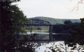
The spectacular Belmar Bridge over the Allegheny River was built in 1907 as part of a railroad
built by local oil man Charles Miller and John D. Rockefeller intended to connect New York with
Chicago. Ultimately, it transported much of the coal from Clarion County to Ashtabula on Lake Erie.
Be sure to climb the stairs to see the river valley from the bridge.

Approximately 8.5 miles south of Franklin is a reminder of the use of the river by Native Americans.
A set of over 50 carvings dating between 1200 and 1750 AD were made on a large rock at the river's
edge. Known as Indian God Rock, this rock is listed on the National Register of Historic Places
and can be easily seen from the trail. An observation deck marks the location.